christian calon
art audio
christian calon
art audio

CONTINENTAL DIVIDE / radio


CONTINENTAL DIVIDE
Chronographie des bassins versants du Canada /
Chronography of the Canadian Watersheds
Production : Deutschlandradio Kultur 2012
Co-production : WestDeutscher Rundfunk
Redaktion : Marcus Gammel
Collaboration aux transcriptions :
Chantal Dumas - Mario Gauthier
Studio d'enregistrement : PRIM, Montréal
Prise de son : Bruno Bélanger, Martin Hurtubise
Création : Deutschlandradio Kultur, Klangkunst, 2 mars 2012
Durée: 52 mn
1 Atlantique 18:51
2 Arctique 11:51
3 Pacifique 20:37
0
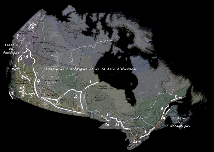
Nous sommes sur le point d’entreprendre un périple sonore de 41.000 km à travers les trois bassins versants majeurs du Canada. Cliquez sur une région ou lisez plus bas.
• • •
We’re about to start a 41.000 km sound journey across the three main watersheds of Canada. Click on a a region or read on.


Entre le très près et le très loin, les points de vue du regardeur.
Considérer la surface visible du continent comme une matière organisée. Une étendue sur laquelle des signes écrits, tracés, griffonés, creusés et effacés par le temps, donne à lire une histoire de la matière et des êtres.
Le paysage est cette histoire qui, si elle ne peut pas révéler sa forme à travers les images trop nombreuses qu’elle propose, pourrait peut-être se raconter par le sonore. C'est notre point de départ.
Transcription
Mais comment transcrire un territoire, un paysage en flux sonore? Grâce à l’apport de nouvelles branches d’étude des Sciences de la Terre, qui repensent en termes perceptifs l’analyse d’un territoire, il m’a été possible de transposer certains concepts et techniques, et trouver des bases d’équivalence entre l’analyse d'un paysage et sa représentation sonore.
À partir d'une masse importante d'images filmées et photographiées le long des 41,000 km de mes parcours à travers le Canada, d’une autre masse tout aussi imposante de documents produits par différents organismes gouvernementaux ou indépendants qui détaillent la topographie, les réseaux hydrographiques, la géographie physique et humaine, la géologie ainsi que l’histoire, il m’a été possible de corroborer des valeurs chiffrées à des données visuelles et tracer la partition qui reprend et décrit les grandes manifestations d’un territoire démesuré et fascinant.
Divisions naturelles
La découverte et le développement du territoire, ses divisions les plus anciennes ont suivi une forme et une contrainte naturelle, celle des bassins versants (les réseaux hydrographiques) que délimitent les lignes de partage des eaux.
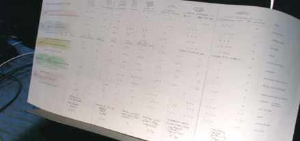
La partition de Continental divide suit exactement cette forme en trois parties (bassin versant Atlantique, Arctique, Pacifique). À l’intérieur de chaque bassin, les divisions naturelles (les écozones) forment chacune un tableau de durée variable.
Une écozone peut-être définie par une combinaison de cinq catégories d'éléments les géographies physique et humaine : le Dénivelé, l’Eau, la Forêt, les Cultures, l’Urbanisation. Chacune de ces catégories est décrite par plusieurs paramètres, notations pour chaque ligne instrumentale ou couches sonores individuelles.
Le passage au son
Une partition détaillée est le résultat de cette analyse du territoire. En parallèle à cette partition, des images-types sont utilisées pour servir de référence visuelle à la matière du territoire. Le rôle des interprètes-improvisateurs est alors de transposer en des actions sonores, une ensemble de contraintes: la fidélité aux indications de la partition, leur interprétation en fonction des images de référence, les indications verbales, une cohésion des articulations internes et l’attention au contexte général de la partition. Cette marge de manoeuvre à la fois très ouverte et très stricte vise à offrir un territoire d'exploration propice à l'invention dans le cadre de l'approche perceptive globale du projet.
L'objectif principal de ce parcours relativement bref, est de permettre une vue d'ensemble et la compréhension de la variété des formes qui composent ce territoire. Ramené à une polyphonie de gestes sonores au déchiffrage de laquelle notre oreille excelle, il m'a semblé qu'en cours de route, un pur plaisir acoustique pourrait même naître de ces révélations d’ordre géomorphologies.
Pour une raison de lisibilité et d'efficacité, nous avons fait le choix d'éviter les sons référentiels provenant de la "nature" qui sont toujours le son d'un lieu et d'un moment unique, pour leur préférer une matière électronique, à priori sans forme et qui se prête mieux aux tracés des lignes de contours sans leur imposer d’image.
Une mise en garde: ce n’est peut-être finalement pas tant de l’espace qu’il s’agit, mais du temps. Pas du son non plus, mais de l’écoute.
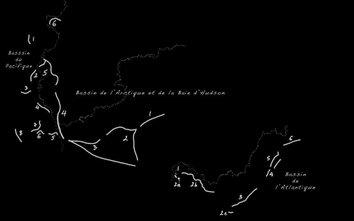


carte agrandie des trois bassins versants et localisation des tableaux sonores. Les pointillés représentent les lignes de partage des eaux / enlarged map of the watersheds with positionning of the sound sequences. The dotted lines represent the divides .
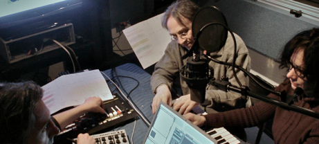
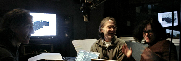
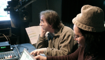
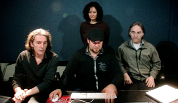
PRIM: les sessions de studio / the studio sessions
Transcription sonore avec Chantal Dumas et Mario Gauthier. À la régie Bruno Bélanger
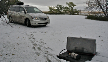
… mais avant, dehors
Prèparer le lunch dans la première tempête de neige en Saskatchewan, boire l’eau du glacier Bow et camper sauvage au Lac Kluane (YT), ignorer les conseils bien fondés et chercher des clochettes et du poivre dans les traces d’Ursus Horribilis.
Afar and near, the viewpoints of the onlooker
Let’s think of the visible surface of the continent as organized matter. An expanse on which time has sketched, scribbled, written, embedded and erased signs which tell a history of matter and beings.
A landscape is a History which may not allow its form to be revealed, burried as it is under the overly numerous images it presents. Its multiplicity may however possibly be told in sound. This is our departure point.
Transcription
New research branches in the Earth Sciences, started analyzing territories in perceptive terms. These foundations provided the tools to transpose the concepts and the techniques they use. It lay the ground for operating modes and the tracing of equivalences between the anlysis of images and the generation of sound materials.
The huge amount of images (film and stills) captured along the 41.00 km journey through the landscape was added to another large amount of research material produced by various government offices or independant institutions.
With these materials in hand it became possible to relate precise data to visual characteristics and undertake the sketching of the score that would represent the form and matter of the wide scale embodiments of the disproportionate and fascinating canadian territory.
Natural divides
The discovery and development of the territory, its older divisions where constrained by natural landmarks : those of the watersheds separated along the lines of the continental divides.
The score behind Continental divide follows precisely the three parts of this large scale form (Atlantic, Arctic, Pacific watersheds). Inside the watersheds, the natural divisions into ecozones form the smaller scale time-sequences of variable duration.
An ecozone can be described as a combination of five categories of elements : the Elevation of terrains, the types and behaviours of Water, the composition of the Forest, the composition of Cultures and the type of the Urbanization. Several parameters describe the major features of each category, and thus represent individual parts in the score (instruments/sound layers).
Into sound
A large score came as a result of this description of the canadian territory. Along with the score, images and film sequences are used to provide a concrete visual reference to the landscape. The role of the performers is to transpose into sound actions a set of constaints: close adhesion to the score, interpretation of the images referencing each region, integration of the verbal indications, looking for cohesion in the performance and keeping an oversight of the general context of the score. This presents an open but very controlled playground which aims at triggering invention and pursues the global perceptive approach of the project.
Somewhere between essay and documentary, the main purpose of the project was to allow a grasp and an understanding of the diversity of forms and matter of this territory. Our ear performing admirably at following polyphonies of lines and textures, a pure acoustical pleasure could even arise along the way, revealing the deep poetical nature, and the ever surprising balance in elements forming what at first sight could be seen as chaos, these rough and wild places we call «nowhere», as well as the magnificent course of rivers while going through geomorphological observations on the nature of space.
Reasons of efficency and comprehension led us to make the choice of leaving aside all sound material coming from "nature" and to concentrate on purely electronic material. Indeed these sounds, basically deprived of form appeared more appropriate for the tracing of outlines without imposing their own "local images".
One last word : the project may in the end not be so much about space than about time, not about sound either, more about listening.
… but before, in the wild
Preparing breakfast in the first Saskatchewan snowstorm, drinking the ancient water from Bow glacier, wild camping on Kluane Lake (YT), deliberately ignoring very sound advices and looking for bells and pepper in the traces of Ursus Horribilis.


Point de départ
Starting point